A police officer directs traffic (Washington, D.C.).
Source: Library of Congress
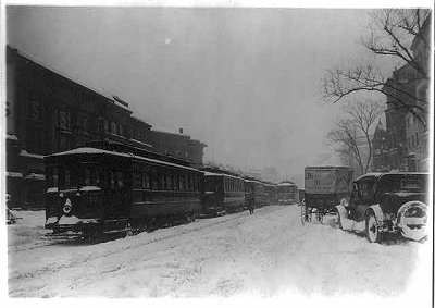
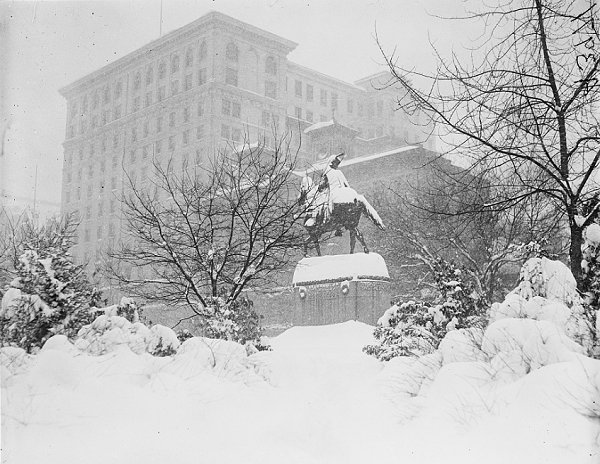
Account from Washington, DC: "Street car traffic was paralyzed this morning [January 28]. Thousands of Government employees residing in outlying sections were compelled to walk because of the tie-up of street car service. They struggled through the knee-deep snow in armies, monopolizing the streets that had been swept somewhat by railway snow plows... The sidewalks were impassable. Street cars, unable to make the switches because of snow jams, in many instances jumped the tracks.
Source: "Capital is Snow-Bound," The Washington Times, January 28, 1922.
Snowfall amounts included:
Connecticut: Bridgeport: 4.5”; Colchester (2 W): 0.5”; Cream Hill: 0.5”; Falls Village: Trace; New London: 3.0”; Norwalk: 2.0”; and, Waterbury: 0.5”
Delaware: Bridgeville (1 W): 15.0”; Delaware City Reedy Point: 18.0”; Dover: 18.0”; Milford (2 SE): 14.0”; and, Wilmington: 18.0”
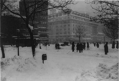
District of Columbia: Washington: 28.0”
Maryland: Aberdeen: 22.0”; Annapolis: 28.0”; Baltimore: 26.5”; Boyds (2 NW): 15.0”; Cambridge: 27.5”; Cecilton: 21.0”; Cheltenham (1 NW): 28.0”; Chesapeake City: 20.0”; College Park: 28.0”; Cumberland: Trace; Denton (2 E): 20.1”; Easton: 25.0”; Emmitsburg: 9.1”; Fallston: 23.3”; Frederick: 10.0”; Friendsville (2 W): 0.5”; Frostburg: 1.0”; Grantsville: 1.1”; Great Falls: 22.5”; Hagerstown: 8.0”; Hancock: 2.2”; Keedysville: 6.0”; La Plata (1 W): 26.0”; Lake Montebello (Baltimore): 26.0”; Laurel (3 W): 28.0”; Millington (1 SE): 20.0”; Oakland (1 SE): 0.5”; Riderwood: 24.0”; Rock Hall: 24.0”; Sabillasville: 8.0”; Salisbury: 9.0”; Snow Hill (4 N): 4.5”; Solomons: 17.5”; Takoma Park: 26.0”; Westernport: 0.1”; and, Westminster (2 SSE): 15.0”
Massachusetts: Bedford: Trace; Boston: 0.1”; Chestnut Hill: 0.3”; Fall River: 2.3”; Hingham: Trace; Milton: 0.5”; New Bedford: 0.5”; and, Somerset: 1.0”
New Jersey: Atlantic City: 8.5”; Belvidere: 5.0”; Charlotteburg Reservoir: 5.0”; Culvers Lake: 3.2”; Dover: 9.0”; Elizabeth: 7.0”; Flemington (5 NNW): 2.0”; Hammonton (1 Ne): 8.0”; Hightstown (2 W): 12.0”; Indian Mills (2 W): 11.0”; Jersey City: 7.8”; Layton (3 NW): 3.0”; Little Falls: 3.0”; Long Branch-Oakhurst: 6.2”; Moorestown: 14.0”; New Brunswick: 6.0”; Newark: 9.0”; Northfield: 12.0”; Paterson: 12.0”; Phillipsburg: 6.2”; Plainfield: 5.5”; Ridgefield: 8.0”; Roebling: 10.0”; Sussex (1 NW): 5.0”; Trenton: 10.8”; and, Vineland: 12.0”
New York: Bedford Hills: 4.2”; Binghamton: Trace; Carmel: 0.5”; Cutchogue: 8.0”; flushing (Queens): 7.5”; Medford: 11.7”; Mount Hope: 5.0”; Mount Vernon: 4.6”; New York City: 6.5”; Port Jervis: 2.0”; Rhinebeck: 0.2”; Roslyn: 6.0”; Scarsdale: 7.0”; Setauket: 6.0”; Walden (2 NE): 2.0”; Wappingers Falls: 1.0”; Warwick: 7.0”; and, West Point: 4.0”
Pennsylvania: Allentown: 13.0”; Altoona: 1.0”; Ardmore: 11.0”; Bellefonte (4 S): 2.0”; Bethlehem: 16.0”; Carlisle: 7.0”; Centre Hall: 1.0”; Chambersburg (1 ESE): 6.6”; Clearfield: Trace; Clymer: Trace; Coatesville (1 SW): 26.0”; Doylestown: 8.0”; Driftwood: Trace; East Stroudsburg: 6.0”; Ephrata: 12.0”; Freeland: 5.0”; Gettysburg: 8.0”; Gouldsboro: 16.0”; Graterford: 1.7”; Greensburg (2 S): Trace; Hamburg: 7.0”; Harrisburg: 9.2”; Hawley (1 E): 12.0”; Huntingdon: 1.5”; Jim Thorpe: 7.0”; Johnstown: 0.2”; Lancaster (2 NE): 15.0”; Lawrenceville (2 S): 0.5”; Lebanon (4 WNW): 9.2”; Lewisburg: 12.0”; Marcus Hook: 9.5”; Matamoras: 2.0”; Mifflintown: 2.3”; Montrose: 3.0”; Muncy Valley: 2.3”; Palmerton: 5.0”; Philadelphia: 12.3”; Phoenixville (1 E): 8.0”; Pottstown: 10.3”; Pottsville: 5.8”; Quakertown: 13.4”; Reading: 11.6”; Ringtown: 6.0”; Sadsburyville: 24.0”; Scranton: 0.8”; Selinsgrove (2 S): 9.0”; Springs (1 SW): 01”; State College: 2.8”; Towanda (1 S): 1.5”; West Chester (2 NW): 18.0”; White Haven: 3.0”; Wilkes Barre: 6.0”; Williamsport: 0.2”; and, York (3 SSW): 14.0”
Rhode Island: Bristol: 1.3”; Kingston: 4.0”; Pawtucket: Trace; and, Providence: 0.5”
Virginia: Blacksburg: 5.8”; Buchanan: 19.0”; Burkes Garden: 2.0”; Callaville: 18.0”; Catawba: 14.0”; Charlottesville: 24.0”; Clarksville: 22.0”; Culpeper: 18.0”; Dahlgren: 12.0”; Dale Enterprise: 6.0”; Danville: 19.0”; Diamond Springs: 0.6”; Fredericksburg National Park: 28.0”; Glen Lyn: 6.0”; Hampton: 2.0”; Hopewell: 13.5”; Hot Springs: 9.5”; Lynchburg: 20.2”; Manassas (3 NW): 32.0”; Mount Weather: 13.0”; Newport News: 8.5”; Norfolk: 3.4”; Pulaski (2 E): 5.5”; Purcellville: 15.0”; Radford: 6.0”; Richmond: 19.1”; Roanoke: 13.0”; Rocky Mount: 14.0”; Runnymede Spottsville: 24.0”; Staunton: 14.0”; Warsaw (2 NE): 14.0”; West Point: 8.0”; Williamsburg (2 NW): 9.2”; Winchester (2 SE): 2.7”; and, Woodstock (2 NE): 5.5”